Template:Short description Template:About Template:Protection padlock Template:Main other{{#invoke:Infobox|infobox}}Template:Template other{{#invoke:Check for unknown parameters|check|unknown=Template:Main other|preview=Page using Template:Infobox settlement with unknown parameter "_VALUE_"|ignoreblank=y | alt | anthem | anthem_link | area_blank1_acre | area_blank1_dunam | area_blank1_ha | area_blank1_km2 | area_blank1_sq_mi | area_blank1_title | area_blank2_acre | area_blank2_dunam | area_blank2_ha | area_blank2_km2 | area_blank2_sq_mi | area_blank2_title | area_code | area_code_type | area_codes | area_footnotes | area_land_acre | area_land_dunam | area_land_ha | area_land_km2 | area_land_sq_mi | area_metro_acre | area_metro_dunam | area_metro_footnotes | area_metro_ha | area_metro_km2 | area_metro_sq_mi | area_note | area_rank | area_rural_acre | area_rural_dunam | area_rural_footnotes | area_rural_ha | area_rural_km2 | area_rural_sq_mi | area_total_acre | area_total_dunam | area_total_ha | area_total_km2 | area_total_sq_mi | area_urban_acre | area_urban_dunam | area_urban_footnotes | area_urban_ha | area_urban_km2 | area_urban_sq_mi | area_water_acre | area_water_dunam | area_water_ha | area_water_km2 | area_water_percent | area_water_sq_mi | blank_emblem_alt | blank_emblem_link | blank_emblem_size | blank_emblem_type | blank_info | blank_info_sec1 | blank_info_sec2 | blank_name | blank_name_sec1 | blank_name_sec2 | blank1_info | blank1_info_sec1 | blank1_info_sec2 | blank1_name | blank1_name_sec1 | blank1_name_sec2 | blank2_info | blank2_info_sec1 | blank2_info_sec2 | blank2_name | blank2_name_sec1 | blank2_name_sec2 | blank3_info | blank3_info_sec1 | blank3_info_sec2 | blank3_name | blank3_name_sec1 | blank3_name_sec2 | blank4_info | blank4_info_sec1 | blank4_info_sec2 | blank4_name | blank4_name_sec1 | blank4_name_sec2 | blank5_info | blank5_info_sec1 | blank5_info_sec2 | blank5_name | blank5_name_sec1 | blank5_name_sec2 | blank6_info | blank6_info_sec1 | blank6_info_sec2 | blank6_name | blank6_name_sec1 | blank6_name_sec2 | blank7_info | blank7_info_sec1 | blank7_info_sec2 | blank7_name | blank7_name_sec1 | blank7_name_sec2 | caption | code1_info | code1_name | code2_info | code2_name | coor_pinpoint | coor_type | coordinates | coordinates_footnotes | demographics_type1 | demographics_type2 | demographics1_footnotes | demographics1_info1 | demographics1_info10 | demographics1_info2 | demographics1_info3 | demographics1_info4 | demographics1_info5 | demographics1_info6 | demographics1_info7 | demographics1_info8 | demographics1_info9 | demographics1_title1 | demographics1_title10 | demographics1_title2 | demographics1_title3 | demographics1_title4 | demographics1_title5 | demographics1_title6 | demographics1_title7 | demographics1_title8 | demographics1_title9 | demographics2_footnotes | demographics2_info1 | demographics2_info10 | demographics2_info2 | demographics2_info3 | demographics2_info4 | demographics2_info5 | demographics2_info6 | demographics2_info7 | demographics2_info8 | demographics2_info9 | demographics2_title1 | demographics2_title10 | demographics2_title2 | demographics2_title3 | demographics2_title4 | demographics2_title5 | demographics2_title6 | demographics2_title7 | demographics2_title8 | demographics2_title9 | dimensions_footnotes | dunam_link | elevation_footnotes | elevation_ft | elevation_link | elevation_m | elevation_max_footnotes | elevation_max_ft | elevation_max_m | elevation_max_point | elevation_max_rank | elevation_min_footnotes | elevation_min_ft | elevation_min_m | elevation_min_point | elevation_min_rank | elevation_point | embed | established_date | established_date1 | established_date2 | established_date3 | established_date4 | established_date5 | established_date6 | established_date7 | established_title | established_title1 | established_title2 | established_title3 | established_title4 | established_title5 | established_title6 | established_title7 | etymology | extinct_date | extinct_title | flag_alt | flag_border | flag_link | flag_size | footnotes | founder | geocode | governing_body | government_footnotes | government_type | government_blank1_title | government_blank1 | government_blank2_title | government_blank2 | government_blank2_title | government_blank3 | government_blank3_title | government_blank3 | government_blank4_title | government_blank4 | government_blank5_title | government_blank5 | government_blank6_title | government_blank6 | grid_name | grid_position | image_alt | image_blank_emblem | image_caption | image_flag | image_map | image_map1 | image_seal | image_shield | image_size | image_skyline | imagesize | iso_code | leader_name | leader_name1 | leader_name2 | leader_name3 | leader_name4 | leader_party | leader_title | leader_title1 | leader_title2 | leader_title3 | leader_title4 | length_km | length_mi | map_alt | map_alt1 | map_caption | map_caption1 | mapsize | mapsize1 | module | motto | motto_link | mottoes | name | named_for | native_name | native_name_lang | nickname | nickname_link | nicknames | official_name | other_name | p1 | p10 | p11 | p12 | p13 | p14 | p15 | p16 | p17 | p18 | p19 | p2 | p20 | p21 | p22 | p23 | p24 | p25 | p26 | p27 | p28 | p29 | p3 | p30 | p31 | p32 | p33 | p34 | p35 | p36 | p37 | p38 | p39 | p4 | p40 | p41 | p42 | p43 | p44 | p45 | p46 | p47 | p48 | p49 | p5 | p50 | p6 | p7 | p8 | p9 | parts | parts_style | parts_type | pop_est_as_of | pop_est_footnotes | population | population_as_of | population_blank1 | population_blank1_footnotes | population_blank1_title | population_blank2 | population_blank2_footnotes | population_blank2_title | population_demonym | population_demonyms | population_density_blank1_km2 | population_density_blank1_sq_mi | population_density_blank2_km2 | population_density_blank2_sq_mi | population_density_km2 | population_density_metro_km2 | population_density_metro_sq_mi | population_density_rank | population_density_rural_km2 | population_density_rural_sq_mi | population_density_sq_mi | population_density_urban_km2 | population_density_urban_sq_mi | population_est | population_footnotes | population_metro | population_metro_footnotes | population_note | population_rank | population_rural | population_rural_footnotes | population_total | population_urban | population_urban_footnotes | postal_code | postal_code_type | postal2_code | postal2_code_type | pushpin_image | pushpin_label | pushpin_label_position | pushpin_map | pushpin_map_alt | pushpin_map_caption | pushpin_map_caption_notsmall | pushpin_map_narrow | pushpin_mapsize | pushpin_outside | pushpin_overlay | pushpin_relief | registration_plate | registration_plate_type | seal_alt | seal_link | seal_size | seal_type | seat | seat_type | seat1 | seat1_type | seat2 | seat2_type | settlement_type | shield_alt | shield_link | shield_size | short_description | subdivision_name | subdivision_name1 | subdivision_name2 | subdivision_name3 | subdivision_name4 | subdivision_name5 | subdivision_name6 | subdivision_type | subdivision_type1 | subdivision_type2 | subdivision_type3 | subdivision_type4 | subdivision_type5 | subdivision_type6 | timezone | timezone_DST | timezone_link | timezone1 | timezone1_DST | timezone1_location | timezone2 | timezone2_DST | timezone2_location | timezone3 | timezone3_DST | timezone3_location | timezone4 | timezone4_DST | timezone4_location | timezone5 | timezone5_DST | timezone5_location | total_type | translit_lang1 | translit_lang1_info | translit_lang1_info1 | translit_lang1_info2 | translit_lang1_info3 | translit_lang1_info4 | translit_lang1_info5 | translit_lang1_info6 | translit_lang1_type | translit_lang1_type1 | translit_lang1_type2 | translit_lang1_type3 | translit_lang1_type4 | translit_lang1_type5 | translit_lang1_type6 | translit_lang2 | translit_lang2_info | translit_lang2_info1 | translit_lang2_info2 | translit_lang2_info3 | translit_lang2_info4 | translit_lang2_info5 | translit_lang2_info6 | translit_lang2_type | translit_lang2_type1 | translit_lang2_type2 | translit_lang2_type3 | translit_lang2_type4 | translit_lang2_type5 | translit_lang2_type6 | type | unit_pref | utc_offset | utc_offset_DST | utc_offset1 | utc_offset1_DST | utc_offset2 | utc_offset2_DST | utc_offset3 | utc_offset3_DST | utc_offset4 | utc_offset4_DST | utc_offset5 | utc_offset5_DST | website | width_km | width_mi | mapframe | mapframe-area_km2 | mapframe-area_mi2 | mapframe-caption | mapframe-coord | mapframe-coordinates | mapframe-custom | mapframe-frame-coord | mapframe-frame-coordinates | mapframe-frame-height | mapframe-frame-width | mapframe-geomask | mapframe-geomask-fill | mapframe-geomask-fill-opacity | mapframe-geomask-stroke-color | mapframe-geomask-stroke-colour | mapframe-geomask-stroke-width | mapframe-height | mapframe-id | mapframe-length_km | mapframe-length_mi | mapframe-marker | mapframe-marker-color | mapframe-marker-colour | mapframe-point | mapframe-shape | mapframe-shape-fill | mapframe-shape-fill-opacity | mapframe-stroke-color | mapframe-stroke-colour | mapframe-stroke-width | mapframe-switcher | mapframe-width | mapframe-wikidata | mapframe-zoom }}{{#invoke:Check for clobbered parameters|check | template = Infobox settlement | cat = Template:Main other | population; population_total | image_size; imagesize | image_alt; alt | image_caption; caption }}{{#if:
|
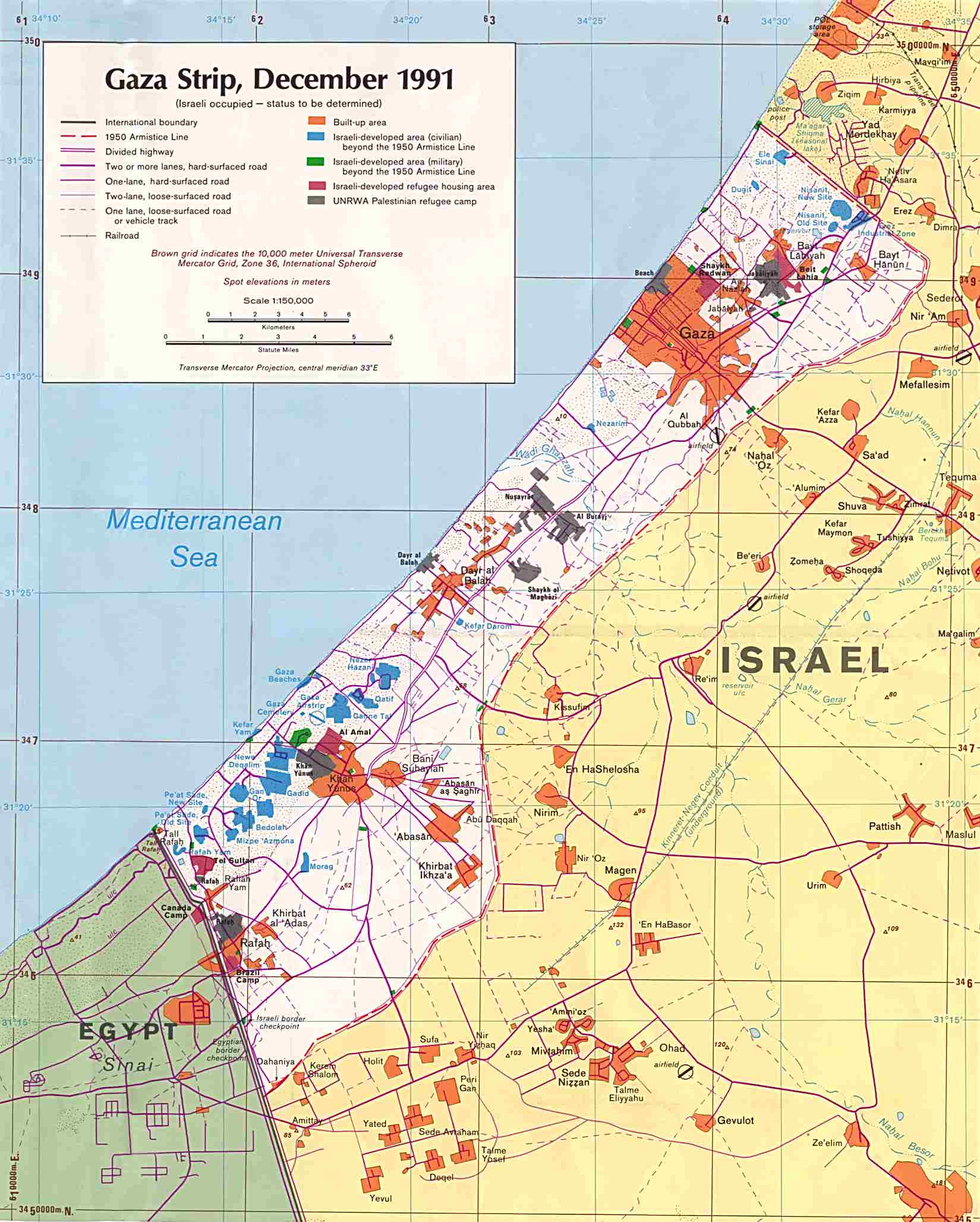
Khan Yunis (Template:Langx), also spelled Khan Younis or Khan Yunus, is a city in the southern Gaza Strip, Palestine, and serves as the capital of the Khan Yunis Governorate. It has been largely destroyed during the Gaza war.
Before the 14th century, Khan Yunis was a village known as "Salqah". A vast caravanserai, today known as Barquq Castle, was constructed there by the emir Yunis al-Nawruzi<ref name=museumwnf>{{#invoke:citation/CS1|citation |CitationClass=web }}</ref> in 1387–88, an official of the Mamluk Empire to protect caravans, pilgrims, and travellers.<ref name=Sharon/>
According to the Palestinian Central Bureau of Statistics, Khan Yunis had a population of 205,125 in 2017.<ref name="PrelimCensus2017" /> Khan Yunis, which lies only Template:Convert east of the Mediterranean Sea, has a semi-arid climate with temperature of 30 °C maximum in summer and 10 °C minimum in winter, with an annual rainfall of approximately Template:Convert.
HistoryEdit
Ancient periodEdit
Herodotus describes a city named Ienysos (Template:Langx) located between Lake Serbonis and Kadytis (modern Gaza city). He talks about how the Persian military marched through the location on its way to Egypt. He also describes how the coastal area between Kadytis and Ienysos was inhabited by local Arab tribes. Some sources, due to phonological resemblance of the names and due to the general matching of the geographic locations, associate this site with modern Khan Yunis.<ref name="Retsö">Retsö, J. (2014). The Arabs in antiquity: Their history from the Assyrians to the Umayyads - "Chapter 9: The Age of the Achaemenids - Herodotus of Halicarnassus". Routledge.</ref>
Other sources have suggested a further inland location of "Khirbet Ma'in Abu Sitta" (Palestinian village depopulated in 1949, near modern kibbutz of Nir Oz)<ref>Abu-Sitta, S. H. (2017). Mapping my return: A Palestinian memoir. American University in Cairo Press.</ref> or the Egyptian town of Arish as possible locations of Ienysos, but there is no clear evidence to support this identification.<ref name="Retsö"/><ref>Template:Cite book</ref>
Ancient discoveries in Khan Yunis feature a lintel with a Greek inscription, discovered repurposed in the tomb of Sheikh Hamada. The inscription translates to: 'Hilarion - giving thanks to St. Georgius.' Originally housed in the Musée de Notre Dame de France in Jerusalem, the lintel is currently lost.<ref>Template:Citation</ref>
Establishment by MamluksEdit
{{#invoke:Labelled list hatnote|labelledList|Main article|Main articles|Main page|Main pages}} Before the 14th century, Khan Yunis was a village known as "Salqah".<ref name=Sharon>Sharon, 1999, p. 228</ref> A vast caravanserai, today known as Barquq Castle, was constructed there by the emir Template:Ill<ref name=museumwnf /> in 1387–88, an official of the Mamluk Empire to protect caravans, pilgrims, and travellers.<ref name=Sharon/> The growing town surrounding it was named "Khan Yunis" after him. Yunus was killed in battle in 1389.<ref>Sharon, 1999, p. 229</ref> Yunus ibn Abdallah an-Nuruzi ad-Dawadar was the executive secretary (Template:Transliteration), one of the high-ranking officials of the Mamluk sultan Barquq. The town became an important center for trade and its weekly Thursday market drew traders from neighboring regions.<ref>Abu-Khalaf, Marwan. Khan Younis City. El-Agha. July 2002.</ref>
The khan served as resting stop for couriers of the barid, the Mamluk postal network in Palestine and Syria.
Ottoman periodEdit
In late 1516 Khan Yunis was the site of a minor battle in which the Egypt-based Mamluks were defeated by Ottoman forces under the leadership of Sinan Pasha. The Ottoman sultan Selim I then arrived in the area where he led the Ottoman army across the Sinai Peninsula to conquer Egypt.<ref>Pitcher, p. 105.</ref> During the 17th and 18th centuries the Ottomans assigned an Asappes garrison associated with the Cairo Citadel to guard the fortress at Khan Yunis.<ref>Hathaway, 2002, p. 38</ref>
Pierre Jacotin named the village Kan Jounes on his map from 1799,<ref>Karmon, 1960, p. 173 Template:Webarchive</ref> while in 1838, Robinson noted Khan Yunas as a Muslim village located in the Gaza district.<ref>Robinson and Smith, vol 3, 2nd appendix, p. 117</ref> In 1863 French explorer Victor Guérin visited Khan Yunis. He found it had about a thousand inhabitants, and that many fruit trees, especially apricots were planted in the vicinity.<ref>Guérin, 1869, p.226 ff, pp. 249-250, p. 251</ref>
During the Ottoman period, the Bedouin tribe of 'Arab al-Wahidat (عرب الوحيدات) were among the residents of Khan Yunis.<ref>Template:Cite journal</ref>
At the end of the 19th-century the Ottomans established a municipal council to administer the affairs of Khan Yunis, which had become the second largest town in the Gaza District after Gaza itself.<ref>Feldman, 2008, p. 21</ref>
British MandateEdit
In the 1922 census of Palestine conducted by the British Mandate authorities, Khan Yunis had a population of 3890 inhabitants (3866 Muslims, 23 Christians, and one Jew),<ref name=Census1922>Barron, 1923, Table V, Sub-district of Gaza, p. 8</ref> decreasing in the 1931 census to 3811 (3767 Muslims, 41 Christians, and three Jews), in 717 houses in the urban area<ref name=censusP4>Mills, 1932, p. 4</ref> and 3440 (3434 Muslims and 6 Christians) in 566 houses in the suburbs.<ref name=censusP5>Mills, 1932, p. 5</ref>
In the 1938 village statistics, the population is listed as 4,379 (including three Jews) with 3,953 in nearby suburbs.<ref>Template:Cite book</ref> In the 1945 statistics, Khan Yunis had a population of 11,220 (11,180 Muslims and 40 Christians),<ref name=1945p31>Department of Statistics, 1945, p. 31</ref> with 2,302 (urban) and 53,820 (rural) dunams of land, according to an official land and population survey.<ref>Government of Palestine, Department of Statistics. Village Statistics, April, 1945. Quoted in Hadawi, 1970, p. 46</ref> Of this, 4,172 dunams were plantations and irrigable land, 23,656 used for cereals,<ref>Government of Palestine, Department of Statistics. Village Statistics, April, 1945. Quoted in Hadawi, 1970, p. 87</ref> while 1,847 dunams were built-up land.<ref>Government of Palestine, Department of Statistics. Village Statistics, April, 1945. Quoted in Hadawi, 1970, p. 137</ref>
During the Nazi occupation of the Dodecanese, many Greeks from Dodecanese islands such as Kastelorizo sought refuge in the nearby Nuseirat Camp.Template:Citation needed
1948–1967Edit
During the night of 31 August 1955, three Israeli paratroop companies attacked the British-built Tegart fort in Khan Yunis from where attacks had been carried out against Israelis.<ref name="Katz" /> The police station, a petrol station and several buildings in the village of Abasan were destroyed, as well as railway tracks and telegraph poles. In heavy fighting, 72 Egyptian soldiers were killed. One Israeli soldier was killed and 17 were wounded. The operation led to a ceasefire on September 4, forcing President Gamal Abdel Nasser and the Egyptian government to halt Palestinian fedayeen operations against Israel.<ref>Derori, 2005, p. 142</ref> One of the mechanized companies was commanded by Rafael Eitan.<ref name="Katz">Katz, 1988, p. 10</ref><ref>Morris, 1993, p. 350</ref>
Before the Suez War, Khan Yunis was officially administered by the All-Palestine Government, seated in Gaza and later in Cairo. After a fierce firefight, the Sherman tanks of the IDF 37th Armored Brigade broke through the heavily fortified lines outside of Khan Yunis held by the 86th Palestinian Brigade.<ref name="Varble, Derek page 46">Varble, 2003, p. 46</ref> It was the only site in the Gaza strip where the Egyptian army put up any resistance to the Israeli invasion of Gaza, but it surrendered on 3 November 1956.
There are conflicting reports of what happened. Israel said that Palestinians were killed when Israeli forces were still facing armed resistance, while the Palestinians said all resistance had ceased by then, and that many unarmed civilians were killed as the Israel troops went through the town and camp, seeking men in possession of arms.<ref name="lat">Template:Cite news</ref><ref name="un" />
The killings, dubbed the Khan Yunis massacre, were reported to the UN General Assembly on 15 December 1956 by the Director of the United Nations Relief and Works Agency, Henry Labouisse. According to the report, the exact number of dead and wounded is not known, but the director received lists of names of persons allegedly killed from a trustworthy source, including 275 people, of which 140 were refugees and 135 local residents.<ref name="un">UNRWA Report to the UN General Assembly November 1 – December 14, 1956 Template:Webarchive.: "The town of Khan Yunis and the Agency's camp adjacent thereto were occupied by Israel troops on the morning of 3 November. A large number of civilians were killed at that time, but there is some conflict in the accounts given as to the causes of the casualties. The Israel authorities state that there was resistance to their occupation and that the Palestinian refugees formed part of the resistance. On the other hand, the refugees state that all resistance had ceased at the time of the incident and that many unarmed civilians were killed as the Israel troops went through the town and camp, seeking men in possession of arms. The exact number of dead and wounded is not known, but the Director has received from sources he considers trustworthy lists of names of persons allegedly killed on 3 November, numbering 275 individuals, of whom 140 were refugees and 135 local residents of Khan Yunis."</ref><ref name="ap">Template:Cite news</ref>
After 1959, the All-Palestine Government of Gaza Strip was abolished and the city was included in the United Arab Republic, which was shortly disestablished and the Gaza Strip came under the direct Egyptian military occupation rule.
1967 and aftermathEdit
In 1967, during the Six-Day War, Israel occupied Khan Yunis again.
As a result of the 1993-1995 Oslo Accords, Khan Yunis and most of the Gaza Strip (excluding Israeli settlements and military areas) were placed under the control of the Palestinian Authority.
Khan Yunis was the site of Israeli helicopter attacks in August 2001 and October 2002 that left several civilians killed, hundreds wounded and civilian buildings within the vicinity destroyed.<ref>{{#invoke:citation/CS1|citation |CitationClass=web }}</ref><ref>Template:Cite news</ref>
The Palestinian Authority came into control of the entirety of the Strip following the 2005 Israeli disengagement. However, following the Battle of Gaza in 2007, Hamas took over the Gaza Strip and established its own government in the region.
Israel–Gaza warEdit
{{#invoke:Labelled list hatnote|labelledList|Main article|Main articles|Main page|Main pages}}
During the ongoing Israel–Gaza war, Israel has bombed Khan Yunis along with other cities in the Gaza Strip as part of an offensive against Hamas. The Israeli Air Force extensively bombed much of the city, including the Hamad City apartment complex.<ref>{{#invoke:citation/CS1|citation |CitationClass=web }}</ref><ref>{{#invoke:citation/CS1|citation |CitationClass=web }}</ref><ref>{{#invoke:citation/CS1|citation |CitationClass=web }}</ref> Local sources have reported numerous civilian casualties in Khan Yunis as a result of Israeli bombings,<ref>{{#invoke:citation/CS1|citation |CitationClass=web }}</ref><ref>{{#invoke:citation/CS1|citation |CitationClass=web }}</ref> which Palestinian news agency Wafa put at "at least 70" as of December 3.<ref>{{#invoke:citation/CS1|citation |CitationClass=web }}</ref> The Al Qarara Cultural Museum was destroyed in an explosion as a result of an Israeli attack in October 2023, part of an offensive that reportedly targeted civilian homes and mosques in the vicinity.<ref>{{#invoke:citation/CS1|citation |CitationClass=web }}</ref><ref>{{#invoke:citation/CS1|citation |CitationClass=web }}</ref> Israeli armored units began entering the outskirts of the city in December 2023. After several months of fighting, Israeli forces ended up withdrawing from Khan Yunis and most of the southern Gaza Strip.<ref>{{#invoke:citation/CS1|citation |CitationClass=web }}</ref><ref>{{#invoke:citation/CS1|citation |CitationClass=web }}</ref><ref>{{#invoke:citation/CS1|citation |CitationClass=web }}</ref> Having failed to root out Hamas from Khan Yunis,<ref>{{#invoke:citation/CS1|citation |CitationClass=web }}</ref><ref>{{#invoke:citation/CS1|citation |CitationClass=web }}</ref> Israeli forces began a second invasion of the city in late July 2024, which also ended in an Israeli withdrawal.<ref>{{#invoke:citation/CS1|citation |CitationClass=web }}</ref> Israeli forces invaded Khan Yunis yet again in August 2024, and withdrew once more at the end of the month.<ref>Template:Cite news</ref> Following the 2025 ceasefire, Hamas forces were seen parading through Khan Yunis.<ref>{{#invoke:citation/CS1|citation |CitationClass=web }}</ref><ref>{{#invoke:citation/CS1|citation |CitationClass=web }}</ref>
EconomyEdit
Khan Yunis is the second largest urban area in the Gaza Strip after Gaza City. It serves as the principal market center of the territory's southern half and hosts a weekly Bedouin souk ("open-air market") mostly involving local commodities.<ref>Thomas, p. 382.</ref> Template:As of Khan Yunis had the highest unemployment rate in the Palestinian territories.<ref>Irving, p. 230.</ref>
EducationEdit
- University College of Science and Technology<ref>University College of Science and Technology Template:Webarchive</ref>
- Al Quds Open University
- Palestine College of Nursing
Notable peopleEdit
- Mohammed Shabir (1946 – 2023), former president of The Islamic University in Gaza
- Yahya Sinwar (1962 - 2024), Palestinian militant and politician who served as chairman of the Hamas Political Bureau from August 2024,<ref name="Al Jazeera 2024-08-06">Template:Cite news</ref> and as the leader of Hamas in the Gaza Strip from February 2017, until his death in October 2024
International relationsEdit
Twin towns – sister citiesEdit
Khan Yunis is twinned with the following cities:
- Template:Flagicon Hamar, Norway
- Template:Flagicon Almuñécar, Spain
- Template:Flagicon Évry, France
- Template:Flagicon Bisceglie, Italy
- Template:Flagicon Alcamo, Italy
See alsoEdit
ReferencesEdit
BibliographyEdit
- Template:Cite book
- Template:Cite book
- Template:Cite book
- Template:Cite book
- Template:Cite book
- Template:Cite book
- Template:Cite book
- Template:Cite book
- Template:Cite journal
- Template:Cite book
- Template:Cite book
- Template:Cite book
- Template:Cite book
- Template:Cite book
- Template:Cite book
External linksEdit
- Khan Younis articles from UNWRA
- Welcome To The City of Khan Yunis
- close-up map of Gaza
- Air photo of Khan Yunis, 1946, with key to sites - Eran Laor Cartographic Collection, The National Library of Israel
Template:Khan Yunis Governorate Template:Cities in Palestinian National Authority areas Template:Hostels Template:Massacres against palestinians Template:Authority control